The Liberty County Emergency Management Agency is currently at OPCON 4 but expects to go to OPCON 3 this evening and to OPCON 2, meaning a full activation of the emergency management operations cell, Wednesday at 8 a.m.
Liberty County EMA also will have a Facebook Live broadcast at 7 p.m. tonight.
A tropical storm warning and a storm surge watch are in effort for Liberty County. As of 2 p.m. Tuesday, the center of Hurricane Idalia was about 560 miles south-southwest of Savannah, moving north at 14 mph with sustained winds of 85 mph.
Hurricane Idalia will continue to track northward across the eastern Gulf of Mexico while further strengthening through tonight. Idalia is forecast to make landfall as a major hurricane in the Big Bend region of Florida on Wednesday morning.
A faster motion toward the north or north-northeast is expected while Idalia approaches the Florida coast through Wednesday morning. Confidence is increasing that Idalia will reach the coast of Florida adjacent to Apalachee Bay on Wednesday morning, with all of the reliable deterministic track models homed in on that area. Track spread remains low during Idalia's expected turn toward the northeast and east-northeast in 48-60 hours, bringing the storm's center near or along the coast of the Carolinas.
Weakening is forecast while the center of Idalia moves over land, but the system is expected to be a tropical storm while it moves near or along the coasts of Georgia and the Carolinas through Thursday.
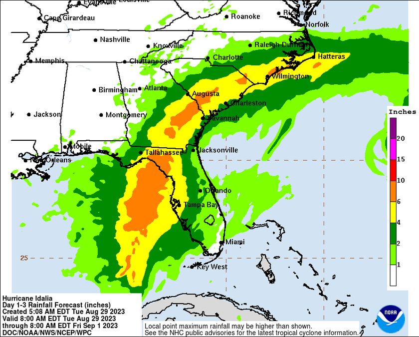
After making landfall, Idalia is expected to track over southeast Georgia and just inland across the southeast South Carolina coastline Wednesday evening through early Thursday morning. Local impacts from Idalia will begin as early as Wednesday morning as heavy rainfall begins to overspread southeast Georgia and southeast South Carolina from southwest to northeast.
Heavy rainfall will then continue through Wednesday night across the region with 4 to 8 inches of rainfall anticipated, with locally greater amounts possible.
Tropical storm force winds are expected to develop across southeast Georgia late Wednesday morning, especially along the coast, with conditions deteriorating Wednesday afternoon and into Wednesday night. Tornadoes will be possible across the area Wednesday afternoon and Wednesday night, particularly along the coast, and waterspouts will be possible across the adjacent Atlantic coastal waters.
Finally, there is the potential for storm surge Wednesday evening through early Thursday morning along the southeast Georgia and southeast South Carolina coasts, where inundation up to 4 feet above ground level is possible.
Potential impacts include:
- Major rainfall flooding could prompt many rescues.
- Rivers and tributaries could rapidly overflow their banks in multiple locations. Small streams, creeks, canals, and ditches may become dangerous rivers. Flood control systems and barriers could become stressed.
- Flood waters could enter many structures within multiple communities; some structures become uninhabitable or are washed away. Flood waters could cover multiple escape routes. Streets and parking lots become rivers of moving water with underpasses submerged. Driving conditions become dangerous. Many road and bridge closures with some weakened or washed out.
- Drinking water and sewer services could be negatively impacted.
- Hazardous containers and materials could be present in flood waters.
Potential impacts from storm surges include:
- Areas of inundation of saltwater along immediate shorelines and in low-lying spots farther inland near rivers and creeks, with storm surge flooding accentuated by waves. Damage to several buildings, mainly near the coast.
- Sections of near-shore escape routes and secondary roads become weakened or washed out, especially in normally vulnerable low spots.
- Moderate to major beach erosion with heavy surf breaching dunes. Strong and numerous rip currents.
- Minor to moderate damage to marinas, docks, boardwalks, and piers. Several small craft broke away from moorings, especially in unprotected anchorages. Some navigation aids possibly displaced well off station, creating difficult navigation near inlets and waterways.
Potential impacts from winds include:
- Considerable roof damage to sturdy buildings, with some window, door, and garage door failures leading to structural damage. Mobile homes may be severely damaged, with some destroyed. Damage accentuated by airborne projectiles. Some locations may be uninhabitable for weeks.
- Danger of death or injury from falling objects and airborne projectiles outside.
- Large trees snapped or uprooted.
- Some roads are impassable from large debris, and more within urban or heavily wooded locations. Several bridges and access routes are impassable.
- Large areas with power and communications outages, which could persist for days.
- Several secured small craft could break free from moorings.
Potential impacts from tornadoes include:
- Isolated to scattered tornadoes can hinder the execution of emergency plans.
- Scattered locations could experience enhanced damage due to tornadoes with a few spots of considerable damage, power loss, and communications failures.
- Scattered locations could realize roofs torn off frame houses, mobile homes demolished, boxcars overturned, large trees snapped or uprooted, vehicles tumbled, and small boats tossed about.
Additional coastal hazards along the entire southeast Georgia and southeast South Carolina coastline including dangerous rip currents, high surf, and beach erosion.
A faster motion toward the north or north-northeast is expected while Idalia approaches the Florida coast through Wednesday morning. Confidence is increasing that Idalia will reach the coast of Florida adjacent to Apalachee Bay on Wednesday morning, with all of the reliable deterministic track models homed in on that area. Track spread remains low during Idalia's expected turn toward the northeast and east-northeast in 48-60 hours, bringing the storm's center near or along the coast of the Carolinas.
Weakening is forecast while the center of Idalia moves over land, but the system is expected to be a tropical storm while it moves near or along the coasts of Georgia and the Carolinas through Thursday.

