
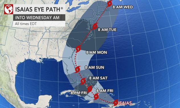
Isaias ramped up to an 80-mph Category 1 hurricane during Thursday night, shortly after pulling away from Hispaniola and will now churn through the Bahamas, just north of Cuba, before making a run along the Eastern seaboard of the United States this weekend to early next week.
This is according to a news release received by the Courier from AccuWeather Meteorologist Alex Sosnowski.
According to the release tropical storm, Isaias lashed Puerto Rico with 60-mph winds and heavy rains and made landfall in the Dominican Republic Thursday afternoon. The storm brought impacts to Haiti, the Dominican Republic's neighbor on the island of Hispaniola, also as it pushed northwest over the Caribbean.
Tropical Storm Isaias was upgraded from Potential Tropical Cyclone Nine status by the National Hurricane Center (NHC) at 11 p.m. EDT Wednesday. The system strengthened as it developed a more organized center with thunderstorms wrapping around its core -- and, with its upgrade, Isaias became the earliest "I-storm" in recorded history. The prior record holder was Irene from Aug. 7, 2005.
Isaias could become the second named system to make landfall in the U.S. in about a week following Hanna's arrival in South Texas on Saturday, July 25. But with the abrupt strengthening during Thursday night, a curved path could keep most of the hurricane-force winds east of the U.S. coastline.