Tropical Depression 4 has strengthened to Tropical Storm Danny and has the potential to become the first hurricane of the 2015 Atlantic season.
The system became a tropical depression on Tuesday morning and could become a hurricane on or before Thursday as the system continues to move through favorable atmospheric conditions in the short term.
The system moved westward across Africa during the first part of August and continues to move westward this week at 10-15 mph (15-25 kph).
According to AccuWeather meteorologist Jordan Root, "Showers and thunderstorms continue to spiral around an area of circulation and organization seems to be increasing as this feature moves through favorable conditions during the middle days of this week."
When a closed circulation near the sea surface has been confirmed, a tropical depression is born. When sustained winds around the circulation reach 39 mph, a tropical depression is upgraded to a tropical storm. For a system to become a hurricane, sustained winds must reach 74 mph.
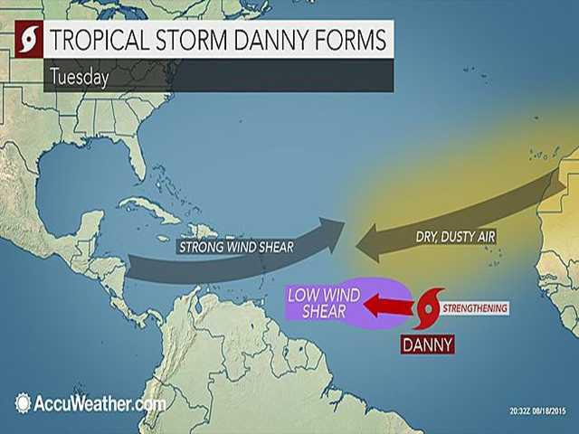
The system is currently almost halfway between the Cape Verde Islands and the Windward Islands just north of the equator and is in a zone where winds aloft are light.
Strong winds aloft can prevent a tropical system from developing or cause an organized tropical system to weaken.
According to AccuWeather meteorologist Evan Duffey, wind shear has been strong over the Caribbean during much of hurricane season thus far.
"The most likely time for the system to strengthen is through Thursday, since beyond this point wind shear is likely to increase as the system approaches and later moves into the Caribbean," Duffey said.
Should the system advance beyond the tropical depression stage it would gather the name Danny, following Ana, Bill and Claudette from earlier this season. None of the first three storms reached hurricane status.
Many of the islands in the Caribbean Sea are in drought and would trade the inconvenience and hazards that a tropical storm would bring for rain. Even a poorly organized tropical depression or storm could bring an uptick in drenching showers and thunderstorms, if the system tracks close by.
The exact track of the system beyond several days is questionable at this point. A track across the Windward or Leeward islands late Monday, then into the Caribbean later next week is most likely, provided the system remains relatively weak. However, a curve to the northwest and dissipation are also possibilities.
Should the system ramp up quickly to a hurricane, then a jog to the northwest would be more likely.
If the system becomes a hurricane, it would be the first of the 2015 Atlantic season.
Another significant area of disturbed weather is forecast to soon emerge off Africa later this week.
"Steering winds favor a more northwest track with this second system when compared to the existing tropical depression and potential impacts to land will likely be reduced, should it develop this weekend into next week," Duffey said.
During El Nino, the number of named tropical systems in the Atlantic basin tends to be lower than average.
AccuWeather is forecasting eight tropical storms, four hurricanes and one major hurricane for the 2015 season with two to three landfalls in the United States. Ana and Bill made landfall in the U.S. during May and June respectively.